Map layers corresponding to the ICCA’s different zoning areas may be seen by ticking on each layer checkbox, which will automatically position the newly ticked layer on top. Layers pertaining to different zones may be seen all at once.
The Kalayunga of Tinoc
Origins
People of Tinoc (formerly Tinek) including the four project sites covering barangays Impugong, Eheb, Tokucan and Ahin are called Kalanguya. The Kalanguya people are among the seven (7) major ethno-linguistic groups in the Cordillera region, northern Luzon, Philippines. The original name “Tinek" conforms to Kalanguya language that stresses on the second syllable that denotes the past tense tinek. Folklore points out that “tinek” is a collective action to save Bugan, wife of legendary leader “Balitok” who is said to have drowned in a pond. Tinek was adopted in honor of Bugan who is remembered for giving much more than what was due to people who worked the fields.
The Kalanguya are closest to their neighboring Ibaloi and Kankanaey tribes of Benguet. They are referred to by Benguet neighbors as I-kadasan or “people who thrive in the kalasan or “oak forest.” They form the dominant group with sub-tribes like the Inangbulan from Impugong and Ibangtinen from Eheb.
The original territory and center of Kalanguya culture is Ahin, one of the four project sites. The first Kalanguya settlements were set up here particularly along the Ahin River. These settlements include Amun Pagey, Amkalew and Duntogto. This would later expand to cover Kalaban, Pulyang, Baliwangwang, Tabo, Paniblayan, Tukguing, Ahin, Bayembeng, Tabuy and Tukucan. Going to Ahin entails 3-4 hours hike uphill. People en route to Tukucan on the other hand entails from 2.5 to 3 hours from the Poblacion.
The Kalanguya form the sub-tribe of Ifugaos alongside the Tuwalis of Western Ifugao covering the municipalities of Hingyon, Lagawe, Kiangan, Asipulo, Hungduan, Banaue. The other major tribe of Ifugao province are the Ayangans in the eastern municipalities of Mayao-yao, Aguinaldo and Alfonso Lista and Lamut located in the south eastern part of the province.
The Province of Ifugao on the other hand forms part of six provinces encompassing the Cordillera Region including: Abra, Apayao, Benguet, Mountain Province, and Kalinga. Although the generic name “Igorot” has been the most familiar designation for the various groups in the Cordillera region, the “tribal” name Kalanguya forms part of regional and tribal names yielded by historical records. At the Kiangan Museum, a description of Ifugaos is written:
The people are called Ifugao by surrounding groups for instance the Gading, to refer to this particular people living in the mountains. The ”I” being a locative particle and the term “Pugo” meaning “hill”, thus, “the people of the hill.” The term is generic one to refer to the group as a whole.
The Kalanguya is therefore a particular sub-group of the Ifugaos.
Barangay Legends
Ahin
Legend has it that an elderly rice field builder named “Dimmangaw,” lived near a spring called “Ah-hinan.” One late afternoon, he poured dried seeds on a pot of water to cook. He maintained the fire with wood sticks even as he kept pouring spring water to soften the seeds. While at it, he fell asleep with the fire wood burning. He woke up the next day to see the pot completely dried, except for a white crystalline particle. Curious, he tasted it. A table salt! Dimmangaw then shared the story to the community, and from thereon, the people started using the crystalline white for food seasoning. This is how the people of the area discovered salt as their widely known resource. From that time on, the villagers called their place “Ahin.”
The people of Ahin bartered salt by engaging in trade with neighboring villages such as in Binalyan, Pampang, Amabaguio and Lo-o. They were called by the people of Benguet as “Iyasin” and by the people of Binalyan, Pampang and Ambaguio, and some parts of Nueva Vizcaya as “Ih-a-hin. Due to political sub-division, the terms “Iyasin” and “I-a-hin” were modified simply as “Ahin.” The arrival of Spanish, American, and Japanese colonizers did not stop this “barter system.” Only after the Halsema Road (Baguio-Bontoc) was constructed and public transport became available did salt from the lowlands gain entry around the area.
Eheb
Eheb’s original name is “Bangtinen.” Access to the place included one pathway. Here, one has to pass through a deep canal called “kulog.” Oral story has it that one night, an old man (mabaki) coming home from work outside the barangay, found that the canal was fenced. It was claimed that a ghost (banig) did the fencing. The old man then was not able to enter the place. So as not to forget the incident and to undertand why, the name Bangtinen was replaced with the name “Eheb,” meaning “fence” in Kalanguya dialect.
Impugong
Impugong is derived from the word “pinugong,” an ancient material used by the Kalanguya to shape tobacco pipes made out of clay, honey and melted silver. An old man continued to make different sizes of pipes for sale. Many users outside the barangay came to Pinugong to buy their tobacco pipes. In 1982, the area was officially created as a new Barangay. Through public consultation, the name “Pinugong” was changed to Impugong.
Tokucan
A place on a high portion of a mountain in the areas was said to have been designated as a site for a community caller to sound off an “alarm.” All village residents would be able to hear the sound when made from this designated site called “Tatkukkan.” Here, the caller brings with him a “Tanggoyob,” a carabao horn. The sound from this horn signals to all “mankailian” or village people, families and neighborhood that a public meeting is being called.
Local account has it that during the World War 11, one Japanese army soldier asked name of the place where the horn blower goes? A native folk answered “Tatkukkan.” The Japanese soldier purportedly responded with, “A, Tukkang!” As an “unforgettable encounter,” locals kept the story, and later, said to have been “improved” by local English teachers as Tokucan. From then on, people called the place Tokucan, resembling the Kalanguya dialect “Tatkukkan.”
Demographics & Geography
Tinoc town is a municipality of the Province of Ifugao bounded by the Province of Benguet on the west, Province of Nueva Vizcaya on the south, municipality of Asipulo, Ifugao on the east, and on the north by Mountain Province. It has four major rivers that flow towards the eastern part of Ifugao down to the lowlands through the town of Lamut, Ifugao and out into Nueva Vizcaya.
Tinoc used to be a barangay of the municipality Hungduan until March 16, 1982 when it became a municipality under Republic Act 184. It added to the Cordillera region’s seventy-eight (78) towns, and among the 12 municipalities of the Province of Ifugao with twelve (12) barangays with a total land area of 25,119 hectares. It is connected to the Halsema National Road through a newly concreted road via the town of Buguias, Benguet. Until 2003 when road concreting began, roads to Tinoc were rugged. It is connected to the mainstream of her mother Province through a road traversing the municipalities of Hungduan and another one via the municipality of Kiangan.
The mossy, pine, agro-forests and shrub lands compose 73.65% of the municipal area. This includes not only the protected forest reserves but also the indigenous owned kubo (settlements) and the kiyewan (forest protected by clans or families). These forest lands store and supply water to the surrounding terraces. Any change in the volume and density of the forest vegetation is expected to radically affect the water supply of the terrace clusters.
Rugged mountainous terrains, high ridges, mossy forested mountain, and deep river valleys make up the area. On the northern part is Mount Kapiligan, 2,700 meters above sea level (masl), and on the south are Mounts Nalicob, 2, 787 masl and Puhel, at 2713 masl. On the east are Mounts Naduntog at 1,715 masl, Baguimbing at 1,830 masl, Amgaday at 2,033 masl, Guibel at 2,249 masl, and Napulawan at 2,642 masl. On the west is Mount Pulag, the highest at 2,932 masl.
The four ICCA project sites are barangays Ahin, Tukucan, Impugong and Eheb all located in the municipality of Tinoc, Province of Ifugao. The four sites cover a total land area of 11,352.1076 hectares broken as follows with Ahin at 6,048.2559 hectares; Tukucan at 2,364.8774 hectares; Impugong at 1, 575, 0661 hectares; and, Eheb at 1,363.9082.
A Community-Based Monitoring and Information Systems (CBMIS) survey made in 2016 by the municipality show a total population of the 4 barangays at 5,125 broken down as follows:
| 1.1 Ahin – | 1,389 | (741 males, 648 females) |
| 1.2 Eheb – | 662 | (346 males, 316 females) |
| 1.3 Impugong – | 1,590 | (814 males, 776 females) |
| 1.4 Tokucan – | 1,489 | (804 males, 680 females) |
Socioeconomic profile
All four ICCA sites share common characteristics with other barangays in the municipality including favorability to agricultural production. The mountains around them exhibit sandy loam soil suitable to temperate crops and fruits. The hilly soils of Impugong, Eheb and Tukucan are sandy due to the presence of a volcanic soil as exhibited by volcanic lacerate lava and sulfur springs. In riverbanks and low-lying lands, the soil is clay loam that indicates rich soil.
Tinoc has an agricultural land area of about 5,802 hectares. It covers irrigated/upland rice land areas; diversified fruit trees farm lands, vegetables and root crop land, mixed fruit tree croplands, and other agricultural lands.
The widest and most prominent is rice land of which 803 hectares are irrigated and 10 hectares un-irrigated. Rice is used to make wine, food, rice yeast and bread like kankanen, tinudok, suman, and bakley. Rice is produced once a year because high-yielding varieties are not introduced in the municipality. The fancy rice/native rice is only planted once a year with an average of 40 cavans of palay per hectare. Some practice the gabot system (lease system) wherein they let others plant and take care of their fields and production will be divided equally.
Crops planted in cultivated areas include: rice, peanut, cash crop vegetables, sweet potato, corn and other vegetables. Carrots, cabbages and sweet peas are the vegetable crops intensively and extensively cultivated and produced because they are high yielding crops. Other vegetable crops like wombok (Chinese pechay), cauliflower, pepper, potatoes and many more are also suitable to the climate in the area. Sweet potato (camote) is a major product of the municipality as a supplement or an alternative to rice. It is harvested 5 to 6 months after planting. The smallest agricultural sector is the banana plantation area.
Tinoc has high potential for agricultural endeavors with the presence of abundant forage grasses, spring water and other local resources supportive to animal production. For livestock raising and production, some practices are hulbeg/manpakkan/manpahtol. This is a practice where, through a mutual agreement with a witness, farmers, sometimes let others raise and take care of their swine, cows, carabaos and dogs on condition that the produce will be divided equally. Native chicken is commonly raised in the municipality as an alternative source of income and for family consumption. Commercial poultry production is not yet introduced in the municipality due to the inaccessibility of support facilities and services supportive to poultry production.
Fishing is a source of livelihood by some farmers in the barangays where swamps, lakes, creeks, rivers are present but on limited scale due to limited technical knowhow of farmers on fish culture. However, the presence of rice field yoyo (loach) adds to the volume of fish production which needs indigenous management along its production.
Most spouses work together as farmers. They commonly do the work especially in vegetable gardening. In the production of native rice, it is the men who plow the fields. After it, the women plant the seedlings and do the weeding.
Culture and traditions
Kalanguya Beliefs and Religion
The kalanguyas believe in a supernatural being which is called kabunyan. Kabunyan to the Kalanguya is the Almighty and Creator of everything both heaven and earth. However, they have not seen yet Kabunyan who is also referred as the Agmatibbew meaning “could not be seen or spirit”.
They believe that kabunyan has some groups of goddesses or deities. The gods and goddesses are thought to be helpers in all kabunyan’s activities all over the earth, like planting and harvesting; birth and death of people and livelihood activities.
Another group of Agmatibbew is the nangketey (they are spirits of the dead ancestors). The kalanguyas believe that they are still obliged to give attention to these nangketey so they offer them animals and food when the sign or omen arises. They believe that these nangketey live in a place given them by kabunyan.
Another group of nanketey is the Bibbiyaw (they are the spirits of people who died a terrible death like accident, murder or suicide). They are believed to be living in big trees, in caves, big rocks or in the forests and mountains. In some instances, they are believed to cause disturbance to the peace and order situation of the people on earth. They give sickness and problems to people and will only be appeased when they are offered animals and foods since that is what they are asking for.
The kalanguyas believe in life after death as proven by their belief of nangketey. The kalanguyas believe that once a person dies, his spirit goes to join his kaapuan (ancestors) in some place. That’s why during the burial they butcher animals and offer food to forebears as presents from their relatives on earth.
This time many of the traditional beliefs and practices are not being practiced especially now with the coming of education and Christianity.
The kalanguyas also believe in the existence of spirits that may cause sickness. When someone gets sick in the family, they go to Maanap (the person who performs the rites). He performs the Anap or Hi-buk (rite) to determine the cause and appropriate ritual to heal the illness.
Traditional management systems
The protection of forests is based on its being considered sacred, being designated by elders as home of the anitos or timmongaw (spirits). This prohibition arises from the belief that evolved into a form of traditional control against unauthorized use of forest lands. It evolved further into customary rule from many years of observation. When such forests are “disturbed and hurt,” the anitos are known to inflict sickness to the person who caused disturbance. Furthermore, the mountains have groups of unseen spirits who are called during events and local feasts including keleng, ibayoh, baki to protect them from any harm and to grace the community with bountiful harvest.
Thus, the kalanguya people prohibit burning and cutting of trees in the forest.The virgin forest or mossy forest should be protected from slash and burn gardening, and swidden farming as such activities result to severe deforestation, soil erosion, soil run off, and loss of water needed for irrigation and other potential industries.
In the ancestral domain, clans led by old folks manages forest/land areas. The identified muyong of a clan or kiyewan of the family clan is maintained for forest products, kaingin and Alung ni danum (watershed).
Forestland consists of the bel-ew or watershed and the Kiyewan or woodlots. Mossy forests are abundant with stunted trees, orchids and dense undergrowth. In Ahin, for example, dipterocarp is found in its warmer portions.
Bel-ew covers higher peaks. Its parts include: 1. Along ni hebheb or springs from which flow potable water flow; 2) along ni danum, or accumulation of many springs that flow down to settlement areas for irrigation via the 3) hayukung (creeks and streams); 4) dowengan, hunting ground; 5) lingenan for bird hunting; 6) tawangan for trapping migratory birds; and 7) pehyew, sites or dwelling areas of spirits. Here, human entry is restricted except when rituals are performed. When maintained, it ensures a gene pool for the community.
Kiyewan are woodlots similar to “muyung” whereby a family assists in regenerating a cultivated swidden farm into a natural forest by planting choice trees and constructing permanent soil erosion control measures. The ”muyung” is a watershed rehabilitation technique, a farming system or an assisted natural regeneration strategy. By doing so, it is a local traditional forest practice that results in conservation.
Burning of dried weeds and farm waste must make certain that fire does not spread, hence, slow firing to make sure the Kiyewan is not affected or damaged. Indiscriminate cutting of saplings to clear a path is prohibited. Cutting may be allowed only if parts of the tree to be cut include only dried twigs and use for firewood.
Biodiversity and ecological significance
Resource Inventory: Determining the State of Health of Forests
The series of transect line inventory conducted throughout the four ICCA sites (October 2017 – January 2018), indicate that Tinoc, as an ancestral domain has a healthy environment. Except for barangay Ahin with two transect lines at one kilometer each line, the Impugong, Tokukan and Eheb had one transect line each.
The four areas encompass 11,352.1076 hectares with about 73% forested areas. Majority of the forests are primary and secondary that covers about 8,328 hectares for all four (4) barangays. For the most part, tree species are endemic dipterocarps and pines.
A total of five (5) 1-km transect lines and fifty five (55) plots were established for this inventory in the forests of Mt. Mangihngihi, Mt. Alibwahen, Mt. Manulibwen, Mt. Il-ilit, Mt. Manap-api, Mt. Mumu-o, and Mt. Nabingit. Eight (8) sample plots of 50m x 50m were distributed and established to the four (4) barangays for carbon quantification on the same forests. Floristic composition, indicative health of the forest using traditional and technical measures, and carbon stock in woody biomass of trees were looked into to provide a descriptive and quantitative analysis of the Kalanguya ICCA.
4.1.1 Floristic Composition
Block and Plot Location and Forest Type
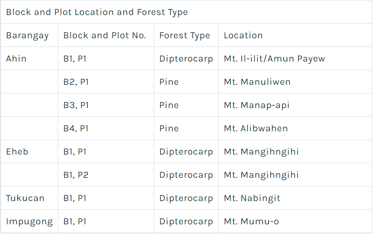
As above shown, the forest type and location of sample plots established were selected based on the forest’s importance to the community. The block is based on forest type and sample plots are distributed to each category.
A total of 229 different kinds of boreal species were documented. The boreal species include tree (120), shrub (45), palm (1), grass (28), herb (3), fern (9), vine (19), epiphyte (1), mushroom (2) and moss (1).
4.1.2 Forest Carbon Stock Assessment
Below is the summary of computation of sample plots following a process of inventory of resources.
| Barangay | Sample Plots (50m x 50m) |
Total Biomass (kg) |
Total Biomass (tons) |
No. of Trees | Average Biomass (tons/tree) |
Plot Area 50m x 50m (ha) |
Average Biomass (tons/ha/year) |
Total Biomass (tons/ha) |
Carbon Stock (tons) |
| Ahin | B1, P1 | 72,622.00 | 72.62 | 493.00 | 0.15 | 0.25 | 0.59 | 290.49 | 32.68 |
| B2, P1 | 98,143.12 | 98.14 | 62.00 | 1.58 | 0.25 | 6.33 | 392.57 | 44.16 | |
| B3, P1 | 85,616.05 | 85.62 | 195.00 | 0.44 | 0.25 | 1.76 | 342.46 | 38.53 | |
| B4, P1 | 210,446.69 | 210.45 | 44.00 | 4.78 | 0.25 | 19.13 | 841.79 | 94.70 | |
| Eheb | B1, P1 | 130,454.29 | 130.45 | 454.00 | 0.29 | 0.25 | 1.15 | 521.82 | 58.70 |
| B2, P1 | 141,271.75 | 141.27 | 280.00 | 0.50 | 0.25 | 2.02 | 565.09 | 63.57 | |
| Tukucan | B1, P1 | 162,366.12 | 162.37 | 521.00 | 0.31 | 0.25 | 1.25 | 649.46 | 73.06 |
| Impugong | B1, P1 | 44,458.04 | 44.46 | 178.00 | 0.25 | 0.25 | 1.00 | 177.83 | 20.01 |
| Total | 945,378.06 | 945.38 | 2,227.00 | 8.31 | 2.00 | 33.22 | 3,781.51 | 425.42 |
As shown, the highest biomass content in kilograms is in B4, P1 with 210.45 of Ahin Pine Forest. This is followed by B1, P1 with 162.37 of Tukucan Dipterocarp Forest. Lowest is in Impugong with 44.46 kilograms of B1, P1. Hence, the highest measured trees are in Tukucan of B1, P1 and the lowest is in Ahin of B4, P1. Furthermore, the eight (8) sampling plots represents the whole ICCA. The area produces 3,781.51 biomass in tons per hectare while total Carbon Stock produces 425.42 tons.
Water resources
The ancestral domain’s forests provide ecological services to outlying municipalities as far as Isabela and Cagayan. It supplies water to three river tributaries leading to the Magat Dam which generate 340 megawatt of electricity and irigating 80,000 hectares of agricultural lands in Isabela. This says a lot about the enormous contribution that traditional governance and natural resource management of Kalanguyas provide to the biodiversity corridor of Northern Luzon.
The four project sites are blessed with natural resources including hot springs, sulfur springs, salt springs and fresh water springs. The sulfur springs in Tukucan and salt springs in Ahin are tonic and medicinal giving eminent and healthful living for the people, while the springs in Eheb are potable. The creeks from Eheb, Tokucan and Impugong formed in Pulyang River links with Ahin River and Tawang River thence passing to Hungduan, Kiangan and Lagawe and out onto the Ibulao River towards the Magat Dam Reservoir. This means that the biggest dam in Asia - Magat Dam - gets its water supply from water sources found in Tinoc, maintained and sustained by traditional governance.
Governance
Within the four barangays are shared commonalities of traditional governance. Clans led by elders manage forest and land areas. The Kiyewan for example is protected under customary rule as “Alung ni danum” (watershed). The Kiyewan is seen as extension of rice fields so that each rice field owner may have source of water supply for his rice field and owner of rice field is bound to protec the Kiyewan. As a rule, each Kiyewan owner is aware and responsible in maintaining boundaries between them. Each owner must ensure that these boundaries are kept. An owner of kiyewan is subject to peer pressure as it is considered a disgrace to pass on to the next generation a Kiyewan without trees.
Generally, the elevated forests above rice terraces are classified as watershed and as source of firewood, lumber and herbal medicine and to some, as sanctuaries. Rice terraces were built along hollows which caught water from the surrounding hills. Above, home of anitos or timmongaw.
Tinoc as an ICCA
“PANGIPEPTEK NI BEL-EW INGEH NI IMPADHING IDAN EMMED TAYO”
Forest Conservation as Inherited from our Ancestors
Ahin, Tokucan, Impugong and Eheb – Tinoc, Ifugao
January 31, 2019
We, the Kalanguya indigenous peoples of the Indigenous Peoples Community Conserved Territories and Areas (ICCA) of Barangays Ahin, Tokucan, Impugong and Eheb, in an assembly here gathered:
Having been bequeathed our Tawid or inherited ancestral lands from our ancestors alongside our fellow Kalanguya indigenous peoples’ communities belonging to the Ancestral Domain of Tinoc municipality, Province of Ifugao, Cordillera Region, Northern Luzon;
Believing, that our traditional resource management systems including our Kiyyewan and Alung ni Danum are the main reasons for our remaining forests and rivers;
Aware, that our rights are enshrined in the 1987 Philippine Constitution, and also stipulated in four (4) bundles of rights[1] under the Indigenous Peoples Rights Act (IPRA), particularly encouraging support for the protection of areas critical for watersheds and wildlife sanctuaries;
Conscious, that under the recently - passed Expanded National Integrated Protected Area Systems Act (E-NIPAS ACT or Republic Act 11308) of 2018, indigenous peoples’ conservation areas and management regimes are duly recognized and respected;
Recalling the terms of the UN Declaration on the Rights of Indigenous Peoples (UNDRIP),[2] and the UN Convention on Biological Diversity (UNCBD), both of which the Philippines is a signatory;
Affirming that for centuries, our traditional governance systems protected our territories long before the aforementioned national and international conservation laws emerged to acknowledge our inherent rights as indigenous peoples. No longer are there any legal doubts in the exercise of our rights, hence, policy harmony between state and traditional governance, in case of doubt should always be ruled or decided in our favor;
Emphasizing self-defined objective, we have translated our knowledge about our Bel-ew or mossy forests, watersheds and rivers into maps[3] thereby providing our community members and decision makers with spatial information for forest protection, planning, monitoring, and capacity to respond to threats;
Emphasizing further, that we pursued inventory of resources[4] to determine the state of health of our forests by examining diversity, evenness and dominance of plant species, as well as determining carbon stock to provide awareness on climate change impacts, mitigation and adaptation;
Advocating, that mapping and resource inventory add to layers of physical evidence and scientific material for effective land use and conservation planning;
Believing that as ICCA pilot sites, this is our modest beginning for “inclusive conservation” even as we invite others to collaborate and support our community-defined terms;[5] particularly our desire to strengthen our traditional management systems over our Kiyyewan, Bel-ew and Alung ni Danum;
Finally, as resource owners, we call for support for the Kalanguya community’s need for incentives including Payment for Ecological Services (PES) mechanism in return for guaranteed flow of ecosystems services. Our Bel-ew and rivers provide services that are economically valuable like irrigation and power generation in outlying provinces including the Magat Dam in the Cagayan Valley.[6] Community trainings and information education campaign on PES can certainly support the conservation and expansion of ecosystems generating services that can be valued in economic and financial terms;
We ask government, the academe and international community and responsible NGOs to support us in this endeavor as we all move and contribute together towards a sustainable future and “leaving no one behind.”
DECLARED this 31ST of January 2019, Poblacion Gym, Tinoc Municipality, Province of Ifugao.
Registered Name
The Kalayunga of Tinoc
Indigenous Name
Tinoc
Location
IFUGAO , CORDILLERA ADMINISTRATIVE REGION (CAR)
Type
Upland
Description
Content under development.
Priority Programs
content under development.
IP Shop
content under development.